
Palm Jebel Ali is located off Dubai’s Jebel Ali coastline, west of Palm Jumeirah and close to Port Jebel Ali, JAFZA and Dubai South. The island connects directly to Sheikh Zayed Road (E11), providing road access towards both central Dubai and Abu Dhabi.
A dedicated 5 km access road links Palm Jebel Ali with the mainland, while its position in western Dubai places destinations such as Dubai Marina, Al Maktoum International Airport and Expo City within relatively easy reach.
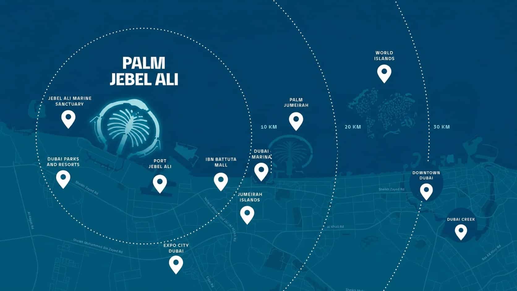
Palm Jebel Ali Location Map
The Palm Jebel Ali location map shows the island off Dubai’s Jebel Ali coastline, west of Palm Jumeirah, with direct connections to the mainland and Sheikh Zayed Road (E11).
Access and Road Connections
Palm Jebel Ali will connect directly to Sheikh Zayed Road (E11) through a dedicated 5 km access road, providing the island with a direct link to Dubai’s principal north-south transport corridor. The masterplan includes three access points to the island, helping distribute traffic across different parts of the development.
From E11, residents and visitors will have direct road connections towards Dubai Marina, central Dubai and Abu Dhabi. Palm Jebel Ali’s position in western Dubai also places it close to major employment and logistics areas including JAFZA and Port Jebel Ali, with Dubai South and Al Maktoum International Airport accessible via the wider road network.
Distances to Key Areas
Palm Jebel Ali’s position in western Dubai provides relatively quick access to Dubai Marina, Expo City and Al Maktoum International Airport, while destinations further east remain accessible via Sheikh Zayed Road.
| Destination | Approx. Drive Time |
|---|---|
| Ibn Battuta Mall | 19 minutes |
| Bluewaters Island | 23 minutes |
| Al Maktoum International Airport (DWC) | 24 minutes |
| Expo City Dubai | 24 minutes |
| Dubai Marina | 25 minutes |
| Palm Jumeirah | 27 minutes |
| Burj Al Arab / Jumeirah | 30 minutes |
| Dubai International Airport (DXB) | 40 minutes |
Nearby Areas and Destinations
Palm Jebel Ali sits within a part of Dubai that includes several major employment, logistics, tourism and future-growth areas. Immediately inland are Port Jebel Ali and Jebel Ali Free Zone (JAFZA), while Dubai South, Expo City Dubai and Al Maktoum International Airport lie further to the southeast.
Along the coast, Palm Jumeirah, Dubai Marina and Bluewaters Island provide useful reference points towards central Dubai, while Dubai Parks and Resorts is located close to the Jebel Ali area. This places Palm Jebel Ali between established coastal Dubai and the expanding Dubai South corridor.
Port Jebel Ali
Major Port & Logistics Hub
JAFZA
Free Zone & Employment Centre
Dubai South
Major Growth District
Dubai Parks & Resorts
Leisure & Entertainment Destination
Brochure Download
Download the Palm Jebel Ali Brochure and discover all this stunning new project has to offer
Location FAQs
How do you get to Palm Jelel Ali?
Palm Jebel Ali is accessed from Sheikh Zayed Road (E11) via a dedicated 5 km access road. Its location provides direct road connections from both Dubai and Abu Dhabi.
How far is it from Palm Jebel Ali to Palm Jumeirah?
Palm Jebel Ali is approximately 27 minutes by car from Palm Jumeirah, although journey times will vary depending on traffic conditions.
What are the Palm Jebel Ali coordinates?
Palm Jebel Ali is located at approximately 25°00’15.5″N, 54°59’19.3″E.
How many access points are there to Palm Jebel Ali?
Palm Jebel Ali is planned with three road access points: the main connection through the central trunk and two additional connections serving either side of the crescent.